Farewell Heights Secondary Plan
The Farewell Heights Secondary Plan* Area covers approximately 107 hectares and is located east of Tooley Road, south of Pebblestone Road, west of Courtice Road, and north of the Adelaide Avenue extension in north Courtice.
Currently, the area includes a mix of agricultural, residential, and commercial uses, along with natural features such as woodlots, wetlands, and Farewell Creek.
The Farewell Heights Secondary Plan will provide more detailed guidance for this area, addressing land uses, transportation, infrastructure, natural heritage, phasing, and urban design.
Draft Preferred Land Use Plan
Residents joined Public Information Centre #3 on June 4, 2025, to learn about the draft preferred land use plan for the Farewell Heights Secondary Plan area and provide their feedback.
The project team provided an update on the Secondary Plan process and presented a preferred land use plan and key policy directions, which were developed based on feedback received from the community at Public Information Centre #2, an online survey, and evaluation by the project team.
Frequently asked questions
Farewell Heights is part of the Courtice Urban Boundary, which means it was planned to accommodate future development. According to Clarington’s Official Plan, the land in this area is mostly designated as “Urban Residential” and “Environmental Protection Area.”
The areas designated “Urban Residential” are mainly for homes, but they can also include things that support a neighbourhood – like schools, parks, and small-scale retail.
The areas marked “Environmental Protection Area” are significant natural spaces that must be protected, conserved, and enhanced. These areas won’t be developed, except for things like walking trails, erosion control, and low impact development stormwater management features.
As shown on Map C of the Clarington Official Plan, a Secondary Plan is to be prepared for the Farewell Heights area to provide a detailed planning framework for these lands.
Secondary Plans are detailed planning documents that outline how specific areas in Clarington will grow and develop to meet the needs of the community. Secondary Plans help determine things like where buildings can go, how tall they can be, what kinds of businesses can operate there, and what roads or parks are needed.
Secondary Plans are created for areas where the Province, the Region and Clarington have already decided that new homes or jobs will be located.
The Farewell Heights Secondary Plan will establish:
- The appropriate mix of land uses (e.g. housing, retail, schools, parks, etc.);
- The height and density of development;
- The road network, as well as trails and transit routes;
- The parkland system; and,
- Protection for the natural environment.
After a Secondary Plan is approved, developers can submit development applications, which are subject to further public consultation and review to assess their alignment with the Secondary Plan.
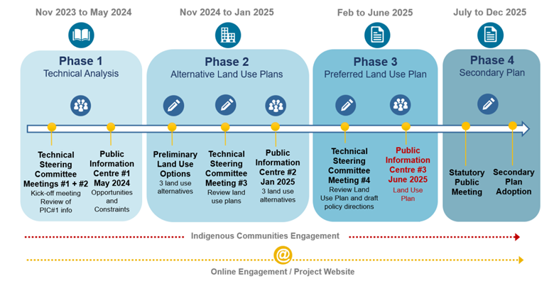
The Farewell Heights Secondary Plan process consists of four phases, each with unique goals, objectives, and deliverables. Public engagement has taken place through multiple Public Information Centres (PICs) and ongoing online surveys to ensure there have been many opportunities to gather and incorporate community feedback.
We continue to welcome feedback on how we can accommodate urban development in this area, while also respecting the existing neighbourhood (both rural and urban residents, as well as the natural environment). We’re currently seeking input on the size and location of parks and open spaces, the type of new housing, and the network of new roads and trails.
All public input gathered throughout this process will be taken into consideration when preparing the draft Secondary Plan, which will be presented at a Statutory Public Meeting in Fall 2025.
The proposed road network currently includes a collector road located just north of Sherry Lane, running parallel to the existing private road. Property owners on Sherry Lane will be invited to an information session this summer to have a focused discussion on this topic.
Protecting drinking water sources is important. Staff have compiled additional information about the tools and processes the Municipality and Region have in place to protect surrounding residents' wells when development occurs. That information is available on this web page under 'Additional Documents'.
The Well Water Information survey is being conducted by R.J. Burnside & Associates Limited on behalf of the Municipality of Clarington. It’s part of Farewell Heights’ background studies and its purpose is to compile information on existing private water supply wells in the Secondary Plan area. The collected information will only be used to create a baseline for existing conditions and to help establish a monitoring and mitigation plan. We encourage residents to fill out the Well Water Information Survey to help with these efforts.
The draft plan currently includes residential lots, about 40 metres (131 feet) deep next to Timberlane Court. These lots are generally 10m (32 feet) deeper than typical lots in low-density neighbourhoods. As currently drafted, the backyards of these 40-metre-deep lots will back onto the backyards of Timberlane Court properties.
For more information, please review the Natural Heritage Evaluation report, which was prepared as part of Phase 1.
The Natural Heritage Evaluation provides a background on existing conditions and identifies potential opportunities and challenges in the Secondary Plan Area related to the natural environment.
In Phase 2, work will continue to finalize the Natural Heritage Evaluation in support of the preferred plan and refine key directions for Farewell Heights. The findings of the Natural Heritage Evaluation will be the basis for developing Secondary Plan policies related to natural heritage protection.
Phase 2 reports will be available for review when the draft Secondary Plan is presented at a Statutory Public Meeting in Fall 2025.
The Secondary Plan process is informed by several technical studies, including a Transportation Study. Phase 1 of the Transportation Study, Existing Conditions, provides an overview of existing transportation conditions, plans, policies, infrastructure and standards to inform a future transportation structure and network for the study area.
Phase 2 of the Transportation Study, which will include operational analysis and recommendations for required road improvements, is being prepared now. The draft Transportation Study will be available for review when the draft Secondary Plan is presented at a Statutory Public Meeting in Fall 2025.
Public meetings and reports
Thank you to everyone who joined us at Public Information Centre #3 on June 4, 2025, to learn about the preferred plan for the Farewell Heights Secondary Plan area. The plan was developed using feedback on three land use options presented at Public Information Centre #2.
Residents joined Public Information Centre (PIC) #2 on January 30 at 6:30 p.m. to learn about three land use options for the Farewell Heights area.
Thank you to everyone who joined us at Public Information Centre #1 to learn about the secondary plan process and findings from the Phase 1 Background Review and Analysis.
The Phase 1 Background Reports provide an inventory and analysis of land use, built form, natural features, transportation, and servicing in the Farewell Heights Secondary Plan study area. The findings of these technical reports will be used as the basis for understanding opportunities and constraints for development.
- Farewell Heights Natural Heritage Evaluation Existing Conditions Report (PDF)
- Farewell Heights Phase 1 Sustainability and Urban Design Report (PDF)
- Farewell Heights Stage 1 Archaeological Report (PDF)
- Farewell Heights Cultural Heritage Existing Conditions Report (PDF)
- Farewell Heights Phase 1 Landscape Analysis Report (PDF)
- Farewell Heights Hydrogeology Existing Conditions Report (PDF)
- Farewell Heights Floodplain Mapping Analysis Report (PDF)
- Farewell Heights Servicing and Master Drainage Plan Existing Conditions Report (PDF)
- Farewell Heights Transportation Existing Conditions Report (PDF)
On December 6, 2021, the Municipality held a Public Meeting to initiate the Farewell Heights Secondary Plan and provided Council and the public with the Terms of Reference.
Materials presented at the Public Meeting were:
- Draft Terms of Reference (PDF)
- Public Meeting Staff Report (PDS-063-21) (PDF)
- Public Meeting Presentation (PDF)
Public comments received:
PLN 41.11
Click on the hotspots to learn more about the draft preferred plan


